
MIAMI – Forecasters continue to say a tropical disturbance in the Caribbean Sea will continue to strengthen as it moves westward at a fast pace and could become a tropical depression on Aug. …
This item is available in full to subscribers.
Please log in to continue |
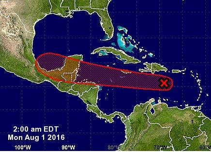
MIAMI – Forecasters continue to say a tropical disturbance in the Caribbean Sea will continue to strengthen as it moves westward at a fast pace and could become a tropical depression on Aug. 1.
Current path predictions have the disturbance headed toward the Yucatan peninsula in Mexico.
Thunderstorm activity associated with the strong and fast-moving tropical wave located over the east-central Caribbean Sea about 200 miles south of the Dominican Republic has increased and become significantly better organized overnight.
Although this system still lacks a closed surface circulation, recent satellite-derived surface wind data and ship observations indicate that tropical-storm-force winds of 40 to 45 mph are occurring on the northern and eastern areas of the large disturbance.
If this recent development trend continues, then a tropical storm could form later Aug. 1 when the wave moves into the central Caribbean Sea, or by early Aug. 2 as it approaches Jamaica and moves into the western Caribbean Sea.
Locally heavy rains and gusty winds are expected over Hispaniola today, and reaching Jamaica and Cuba by late Monday as the system moves westward at 20 to 25 mph. Interests in these areas and elsewhere in the western Caribbean Sea should continue to monitor the progress of this strong disturbance.
For additional information on this system, see High Seas Forecasts issued by the National Weather Service.
Formation chance through 48 hours is high at 70 percent and formation chance through five days is also high at 80 percent.
Another tropical wave that was farther east and heading on basically the same path has dissipated.


